Thursday, August 2, 2012

Marine Radar Onboard Ships: An Overview


Marine Radar Onboard Ships: An Overview


Marine radar is an indispensable tool in modern maritime navigation, providing critical information that ensures the safety and efficiency of ships at sea. This comprehensive guide explores the intricacies of marine radar, its components, types, functions, and the technological advancements that have revolutionized its use.

Introduction

Marine radar is a vital navigational aid that helps detect and track objects such as other vessels, landmasses, buoys, and navigational hazards. It operates by emitting radio waves that reflect off objects, with the reflected signals processed to determine the object's distance, direction, speed, and course. This information is crucial for safe navigation, especially in poor visibility conditions such as fog, rain, or nighttime.

Historical Background

The development of radar technology dates back to the early 20th century, with significant advancements during World War II. Initially used for military applications, radar technology was adapted for maritime use to enhance navigation safety. The first marine radars were large and cumbersome, but technological advancements have made them more compact, efficient, and user-friendly.

Types of Marine Radar

Marine radar systems are broadly classified into two types based on the frequency bands they operate in: S-band radar and X-band radar.

  • S-band Radar: Operating at a frequency of around 3 GHz, S-band radar is capable of penetrating rain, fog, and sea clutter more effectively. It offers longer-range detection and is ideal for tracking large targets such as ships and landmasses. S-band radar is particularly useful in adverse weather conditions.
  • X-band Radar: Operating at a higher frequency of around 9 GHz, X-band radar provides higher resolution and sharper images. It is more sensitive to small targets like buoys and fishing boats. However, it can be more susceptible to weather conditions. X-band radar is commonly used for collision avoidance and navigation in congested waterways.

Main Components of Marine Radar

A typical marine radar system consists of three main components:

  1. Antenna: The antenna emits radio waves and rotates continuously to cover a 360-degree area. It receives the reflected signals from objects in its path. There are two primary types of antennas used in marine radar:
    • Open Array Antenna: Known for its higher gain and better performance, especially in distinguishing closely spaced targets.
    • Radome Antenna: Enclosed in a protective dome, it is more compact and suited for smaller vessels.
  2. Transmitter/Receiver Unit: This unit generates the radio waves emitted by the antenna and processes the returned signals. It calculates the range, bearing, speed, and course of detected targets.
  3. Display Unit: The display unit shows the radar picture on a screen, which can be either a cathode ray tube (CRT) or a liquid crystal display (LCD). Modern radar systems often use high-resolution LCD screens for clearer images and enhanced user interaction.

Functions of Marine Radar

Marine radar performs several critical functions that enhance navigational safety and operational efficiency:

  • Detection and Tracking: Marine radar identifies and tracks various objects, including other vessels, landmasses, buoys, and navigational hazards. This capability is vital for situational awareness.
  • Navigation Aid: Radar provides essential information that aids in navigation through restricted visibility conditions. It helps mariners plot courses, identify safe passages, and avoid hazards.
  • Collision Avoidance: One of the primary functions of marine radar is to prevent collisions at sea. Radar provides bearing and distance information about other vessels, enabling navigators to take evasive action when necessary.
  • Automatic Radar Plotting Aid (ARPA): ARPA systems enhance radar functionality by automatically tracking the movement of multiple targets. ARPA calculates the closest point of approach (CPA) and the time to closest point of approach (TCPA), helping navigators assess collision risks and make informed decisions.
  • Search and Rescue Operations: Marine radar is crucial in search and rescue missions, helping locate distressed vessels or individuals in the water.

Technological Advancements in Marine Radar

The marine radar industry has seen significant technological advancements, improving its functionality and usability:

  • Solid-State Technology: Traditional magnetron-based radars are being replaced by solid-state radar technology, which offers better performance, reliability, and lower maintenance requirements.
  • Broadband Radar: Broadband radar systems provide higher resolution and better target discrimination, especially at close ranges. They are particularly effective in detecting small targets and navigating in congested areas.
  • Integration with Other Systems: Modern marine radar systems are often integrated with other navigational tools, such as Electronic Chart Display and Information Systems (ECDIS) and Automatic Identification Systems (AIS). This integration provides a comprehensive view of the navigational environment.
  • User-Friendly Interfaces: Advances in user interface design have made marine radar systems more intuitive and easier to operate. Touchscreen displays, customizable interfaces, and advanced plotting features enhance the user experience.
  • Environmental Adaptability: Modern radars can adjust their settings based on environmental conditions, optimizing performance in various weather and sea states.

Some of the main features of marine radar with ARPA integration are:

  • Range scale: This is the maximum distance that the radar can cover. It can be adjusted by using the range key on the keyboard or by selecting from a menu on the screen. The range scale determines the size and resolution of the radar picture.
  • Range rings: These are concentric circles that divide the radar screen into equal intervals. They help to measure the range of a target by counting the number of rings between the center of the display and the target echo.
  • Variable range marker (VRM): This is a dashed circle that can be moved by using a scroll wheel or a trackball. It gives more accurate range measurements than range rings by touching the inner edge of the target echo.
  • Electronic bearing line (EBL): This is a straight line that extends from the own ship’s position to any point on the screen. It gives more accurate bearing measurements than  compass rose by aligning with any target echo.
  • Parallel index line (PI): This is a dashed line parallel to EBL that indicates how far off course or off-track own ship is from its intended course or track.
  • Heading marker: This is an arrow at 0°T on top of EBL that shows own ship’s heading relative to true north.
  • Course over ground (COG) vector: This is an arrow at own ship’s position that shows own ship’s course over ground relative to true north.
  • Speed over ground (SOG) vector: This is an arrow at own ship’s position that shows own ship’s speed over ground relative to true north.
  • True motion mode: This is a mode where own ship moves across the screen while targets remain stationary relative to true north.
  • Relative motion mode: This is a mode where own ship remains stationary at the center of the screen while targets move across it relative to own ship.

Here are some tips on how to use marine radar effectively:

  • Adjust gain control: Gain control adjusts the sensitivity of the radar receiver. It should be set so that background noise is just visible on screen without obscuring weak echoes from small targets or distant targets.
  • Adjust sea clutter control: Sea clutter control reduces unwanted echoes from the sea surface caused by waves or swell. It should be set so that sea clutter does not interfere with target detection near the horizon or close range.
  • Adjust rain clutter control: Rain clutter control reduces unwanted echoes from precipitation caused by rain or snow. It should be set so that rain clutter does not interfere with target detection in areas affected by weather conditions.
  • Select appropriate range scale: Range scale should be selected depending on prevailing circumstances and conditions such as traffic density, proximity to the coastline, visibility etc. A longer range scale provides advance warning of approaching targets while shorter range scale provides better resolution for close-range targets.
  • Use VRM and EBL for accurate measurements: VRM and EBL provide more accurate measurements than fixed range rings and compass rose for target’s range and bearing respectively. They also help to determine if there is a risk of collision by checking if the bearing remains constant with decreasing range.
  • Use PI line for course keeping: PI line helps to keep own ship on its intended course or track by showing how far off it deviates from it due to wind, current etc. It also helps to estimate closest point of approach (CPA) with other vessels by showing how much clearance there will be between them at crossing situation.

 COMMON PROBLEMS ON MARINE RADAR

Marine radar is not without its challenges and limitations. Some of the problems that can affect the performance and accuracy of marine radar are:

  • Clutter: Clutter refers to unwanted echoes or noise on the radar screen that can obscure or confuse the real targets. Clutter can be caused by various factors, such as rain, snow, fog, sea waves, birds, insects, interference from other radars or electronic devices, etc. To reduce clutter, the radar operator should adjust the gain control (sensitivity) so that only the relevant echoes are visible on the screen. The operator should also use filters or suppressors to eliminate specific types of clutter.
  • Blind zones: Blind zones are areas where the radar cannot detect targets due to physical obstructions or limitations of the antenna. For example, blind zones can occur behind tall structures (such as masts or funnels), below or above the horizon (due to earth’s curvature), or close to own ship (due to minimum range). To avoid blind zones, the operator should use different range scales or switch between X-band (shorter wavelength) and S-band (longer wavelength) radars if available.
  • False echoes: False echoes are misleading signals that appear on the radar screen but do not correspond to real targets. False echoes can be caused by various factors, such as reflection from land features (such as mountains or buildings), refraction from atmospheric layers (such as inversion or ducting), multipath propagation (when radio waves bounce off more than one surface), etc. To identify false echoes, the operator should compare them with visual observations or other sources of information (such as AIS or VHF).
  • Shadow sectors: Shadow sectors are areas where a target is hidden from view by another target that is closer to own ship. For example, a small boat behind a large ship may not be visible on radar due to shadowing effect. To avoid shadow sectors, the operator should use different bearing lines or electronic bearing lines (EBLs) to measure the relative bearings of targets from own ship.
  • Sea return: Sea return is a type of clutter that occurs when radio waves reflect off sea surface due to rough weather conditions or high wind speed. Sea return can mask small targets near own ship or create false targets at longer ranges. To reduce sea return, the operator should adjust sea clutter control (STC) which reduces sensitivity at short ranges.


Conclusion

Marine radar is an essential tool for maritime navigation, providing critical information that ensures the safety and efficiency of vessels at sea. From detecting and tracking objects to aiding in collision avoidance and search and rescue operations, marine radar plays a pivotal role in modern maritime operations. Technological advancements continue to enhance its capabilities, making it an indispensable asset for mariners worldwide.


Wednesday, August 1, 2012

Gyroscope


REPET

250px-3D_Gyroscope

Your Guide to Seafaring

Earth is a example of gyroscope turning from east to west.

Here are your Keywords.

Gyroscopic Inertia – Maintain Orientation

Gyroscopic Precession – Change direction at right angle.

Phantom – support gyroscope.

Gyro Compass Error

Speed Error – Seek at setting position

Quadrantal Error – Swing from side to side.

Gimbaling Error – Tilt, Gimbals


gyroscope is a device used for measuring or maintaining orientation and angular velocity. It operates based on the principles of angular momentum and has applications in navigation, stabilization, and various technologies. Here’s an in-depth look at gyroscopes, their types, functions, and applications.

Principle of Operation

The core principle behind a gyroscope is angular momentum. When a rotating object, such as a disk, is subjected to an external torque, it resists changes to its axis of rotation. This resistance allows the gyroscope to maintain its orientation.

Types of Gyroscopes

  1. Mechanical Gyroscopes: The classic form, consisting of a spinning wheel or disk. These gyroscopes use the principles of angular momentum to maintain orientation.
  2. Ring Laser Gyroscopes (RLGs): Utilize laser beams traveling in opposite directions in a circular path. The interference pattern of these beams provides information about the rate of rotation.
  3. Fiber Optic Gyroscopes (FOGs): Similar to RLGs but use fiber optic cables to guide light. They are highly accurate and used in various high-precision applications.
  4. MEMS Gyroscopes: Micro-Electro-Mechanical Systems gyroscopes are compact and widely used in consumer electronics like smartphones and drones. They use vibrating structures to measure angular velocity.

Applications of Gyroscopes

  1. Navigation: Gyroscopes are integral to inertial navigation systems (INS) used in aircraft, ships, and spacecraft. They provide critical information about orientation and movement.
  2. Stabilization: In cameras, ships, and drones, gyroscopes help stabilize the platform by detecting and compensating for unwanted motion.
  3. Consumer Electronics: Smartphones, gaming controllers, and VR headsets use MEMS gyroscopes for orientation detection and motion tracking.
  4. Aerospace and Defense: High-precision gyroscopes are used in missile guidance systems, aircraft navigation, and satellite orientation control.

Conclusion

Gyroscopes play a crucial role in modern technology, offering precise measurements and stabilization across various applications. From smartphones to spacecraft, these devices have revolutionized our ability to navigate, stabilize, and interact with the world around us. 

Moon Phase


moon_phases_diagram

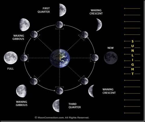
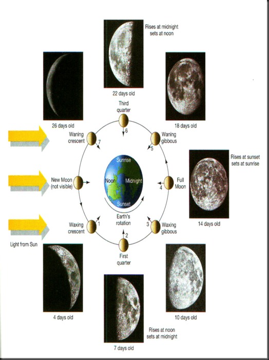
The Moon exhibits different phases as the relative position of the Sun, Earth and Moon changes, appearing as a full moon when the Sun and Moon are on opposite sides of the Earth and as a new moon (dark moon) when they are on the same side. The phases of full moon and new moon are examples of syzygies, which occur when the Earth, Moon, and Sun lie (approximately) in a straight line. The time between two full moons (a Lunar month) is about 29.53 days (29 days, 12 hours, 44 minutes 2.8 seconds) on average (hence, the concept of the time frame of an approximated month was derived). This Synodic month is longer than the time it takes the Moon to make one orbit around the Earth with respect to the fixed stars (the Sidereal month), which is about 27.32 days (27 days, 7 hours, 43 minutes 11.5 seconds).This difference is caused by the fact that the Earth-Moon system is orbiting around the Sun at the same time the Moon is orbiting around the Earth.
The orbit of the moon  is very nearly circular (eccentricity 0.05) with a mean separation from the earth of about 384,000 km. which is about 60 earth radii. The plane of the orbit is tilted about 5 degrees with respect to the plane.
moon-8

Moonphases

moon-phases-101111-02

Priming -  New Moon to 1st Quarter (1-3) / Full Moon to 3rd Quarter (5-7)
Lagging – 1st Quarter to Full Moon (3-5) / 3rd Quarter to New Moon (7-1)
Waxing Moon – The Moon between new and full when its visible part is increasing.
Waning Moon – The moon between full and new and when its visible part is decreasing.
Harvest Moon – The full moon nearest  the autumnal equinox.
Hunters Moon – The full moon one month after the autumnal equinox.
Neap Tides (1st Quarter or 3rd Quarter)
Spring Tides  (New Moon and Full Moon)
Position
Phase
Age (days)
Rise
1 New Moon 0 6 AM
2 1st Quarter 7 1/4 12 NN
3 Full Moon 14 1/2 18 PM
4 3rd Quarter 21 3/4 24 PM
moonphases

Beaufort Wind Scale

Your Guide to Seafaring

The Beaufort Wind Scale is an empirical measure that relates wind speed to observed conditions at sea or on land1. Developed in 1805 by Sir Francis Beaufort, a British Royal Navy officer, the scale has been an essential tool for mariners, meteorologists, and various fields beyond since its inception2.

Historical Background

Sir Francis Beaufort devised the scale while serving on HMS Woolwich1. Initially, the scale was based on the effects of wind on a ship's sails, ranging from "just sufficient to give steerage" to "that which no canvas sails could withstand."1 Over time, the scale was refined and extended to include land observations, making it more versatile and widely applicable1.

Beaufort

Number

Speed(kn)

Speed (mph)

Speed (km/h)

Description

Wave Height (meters)

0

0-1

0-1

0-1

Calm

Sea like a mirror

1

1-3

1-3

1-3

Light Air

Sea with ripples

2

4-6

4-7

4-6

Light Breeze

Small wavelets

3

7-10

8-12

7-10

Gentle Breeze

Large wavelets

4

11-16

13-18

11-16

Moderate Breeze

Small waves

5

17-21

19-24

17-21

Fresh Breeze

Moderate waves

6

22-27

25-31

22-27

Strong Breeze

Large waves

7

28-33

32-38

28-33

Near Gale

High waves

8

34-40

39-46

34-40

Gale

Very high waves

9

41-47

47-54

41-47

Severe Gale

High waves

10

48-55

55-63

48-55

Storm

Very high waves

11

56-63

64-72

56-63

Violent Storm

Exceptionally high waves

12

64+

73+

64+

Hurricane

Devastation


Modern Scale

The Beaufort Wind Scale is divided into 13 levels, ranging from 0 (calm) to 12 (hurricane force)1. Each level is associated with specific wind speeds, observed conditions, and probable wave heights3. Here's a detailed breakdown:

Functions and Applications

The Beaufort Wind Scale is widely used in maritime navigation, weather forecasting, and environmental monitoring1. It helps mariners assess wind conditions and make informed decisions to ensure safe navigation. Meteorologists use the scale to describe wind conditions in weather reports, and it is also used in various industries to assess the impact of wind on structures and activities.

Conclusion

The Beaufort Wind Scale remains a valuable tool for understanding and communicating wind conditions. Its simplicity and practicality have made it a staple in maritime and meteorological practices for over two centuries. By providing a standardized way to measure and describe wind speeds, the Beaufort Wind Scale continues to play a crucial role in ensuring safety and efficiency in various fields.


Wind Circulation


               circ

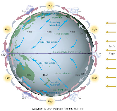
Around the equator there is a belt of relatively low pressure known as the doldrums, where the heated air is expanding and rising; at about lat. 30°N and S there are belts of high pressure known as the horse latitudes, regions of descending air; farther poleward, near lat. 60°N and S, are belts of low pressure, where the polar front is located and cyclonic activity is at a maximum; finally there are the polar caps of high pressure.

The prevailing wind systems of the earth blow from the several belts of high pressure toward adjacent low-pressure belts. Because of the earth's rotation (see Coriolis effect), the winds do not blow directly northward or southward to the area of lower pressure, but are deflected to the right in the Northern Hemisphere and to the left in the Southern Hemisphere. The wind systems comprise the trade winds; the prevailing westerlies, moving outward from the poleward sides of the horse-latitude belts toward the 60° latitude belts of low pressure (from the southwest in the Northern Hemisphere and from the northwest in the Southern Hemisphere); and the polar easterlies, blowing outward from the polar caps of high pressure and toward the 60° latitude belts of low pressure.

These are your Keywords:

Doldrums (5°N to 5°S)
Diurnal pressure variation is most noticeable. Low Pressure belt near the Equator.

Trade Winds (5° - 30° N/S)
Greatest Effect on set, drift, depth of equatorial currents. Fine clear Weather.

Horse Latitudes (30° - 35° N/S)
Diurnal pressure variation is commonly observe. Region of high pressure extending around earth 35°. Pole side of trade winds belt area of high pressure.


Motion Of The Ship


ce619600fg0010
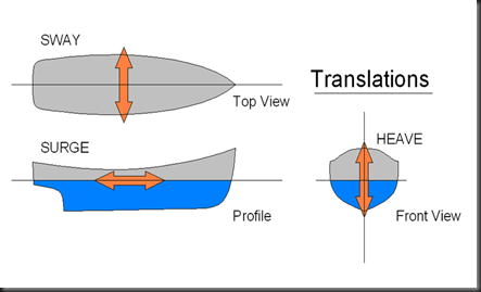
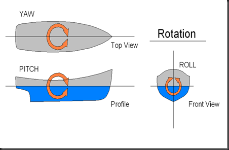
Ship motions are defined by the six degrees of freedom that a ship, boat or any other craft can experience.


800px-Translations

Heave
is the linear vertical (up/down) motion
Sway
is the linear lateral (side-to-side) motion
Surge
is the linear longitudinal (front/back) motion


800px-Rotations


Roll
is when the vessel rotates about the longitudinal (front/back) axis
Pitch
is when the vessel rotates about the transverse (side-to-side) axis
Yaw
is when the vessel rotates about the vertical (up-down) axis

Types Of Clouds


T_38298

Cloud Types

Most clouds are associated with weather. These clouds can be divided into groups mainly based on the height of the cloud's base above the Earth's surface. The following table provides information about cloud groups and any cloud classes associated with them. In addition, some clouds don't fall into the categories by height. These additional cloud groups are listed below the high, middle, and low cloud groups.


High-Level Clouds High-level clouds form above 20,000 feet (6,000 meters) and since the temperatures are so cold at such high elevations, these clouds are primarily composed of ice crystals. High-level clouds are typically thin and white in appearance, but can appear in a magnificent array of colors when the sun is low on the horizon.

Cirrus

Cirrus clouds are the most common of the High Cloud (5000-13000m) group. They are composed entirely of ice and consist of long, thin, wispy streamers. They are commonly known as "mare's tails" because of their appearance.
Cirrus clouds are usually white and predict fair weather.

Cirrocumulus

Cirrocumulus clouds belong to the High Cloud group (5000-13000m). They are small rounded puffs that usually appear in long rows. Cirrocumulus are usually white, but sometimes appear gray. Cirrocumulus clouds are the same size or smaller than the width of your littlest finger when you hold up your hand at arm's length.
If these clouds cover a lot of the sky, it is called a "mackerel sky" because the sky looks like the scales of a fish. Cirrocumulus are usually seen in the winter time and indicate fair, but cold weather.

Cirrostratus

Cirrostratus clouds belong to the High Cloud (5000-13000m) group. They are sheetlike thin clouds that usually cover the entire sky.
The sun or moon can shine through cirrostratus clouds . Sometimes, the sun or moon will appear to have a halo around it when in the presence of cirrostratus. The ice crystals from the cloud refracts the light from the sun or moon, creating a halo. This halo is the width of your hand when you hold it out at arm's length.
Cirrostratus clouds usually come 12-24 hours before a rain or snow storm. This is especially true if Middle group clouds are associated with it.


Mid-Level Clouds The bases of mid-level clouds typically appear between 6,500 to 20,000 feet (2,000 to 6,000 meters). Because of their lower altitudes, they are composed primarily of water droplets, however, they can also be composed of ice crystals when temperatures are cold enough.

Altocumulus

Altocumulus clouds are part of the Middle Cloud group (2000-7000m up). They are grayish-white with one part of the cloud darker than the other. Altocumulus clouds usually form in groups and are about 1 km thick.
Altocumulus clouds are about as wide as your thumb when you hold up your hand at arm's length to look at the cloud.
If you see altocumulus clouds on a warm humid morning, then expect thunderstorms by late afternoon.

Altostratus

Altostratus belong to the Middle Cloud group (2000-7000m up). An altostratus cloud usually covers the whole sky and has a gray or blue-gray appearance. The sun or moon may shine through an altostratus cloud, but will appear watery or fuzzy.
An altostratus cloud usually forms ahead of storms with continuous rain or snow. Occasionally, rain will fall from an altostratus cloud. If the rain hits the ground, then the cloud becomes classified as a nimbostratus cloud.


Low-level Clouds Low clouds are of mostly composed of water droplets since their bases generally lie below 6,500 feet (2,000 meters). However, when temperatures are cold enough, these clouds may also contain ice particles and snow.


Stratus

Stratus clouds belong to the Low Cloud (surface-2000m up) group. They are uniform gray in color and can cover most or all of the sky. Stratus clouds can look like a fog that doesn't reach the ground.
Light mist or drizzle is sometimes associated with stratus clouds.

Stratocumulus

Stratocumulus clouds belong to the Low Cloud (surface-2000m) group. These clouds are low, lumpy, and gray. These clouds can look like cells under a microscope - sometimes they line up in rows and other times they spread out.
Only light precipitation, generally in the form of drizzle, occurs with stratocumulus clouds. To distinguish between a stratocumulus and an altocumulus cloud, point your hand toward the cloud. If the cloud is about the size of your fist, then it is stratocumulus.

Nimbostratus

Nimbostratus clouds belong to the Low Cloud (surface to 2000m up) group. They are dark gray with a ragged base. Nimbostratus clouds are associated with continuous rain or snow. Sometimes they cover the whole sky and you can't see the edges of the cloud.

Cumulonimbus

Cumulonimbus clouds belong to the Clouds with Vertical Growth group. They are generally known as thunderstorm clouds. A cumulonimbus cloud can grow up to 10km high. At this height, high winds will flatten the top of the cloud out into an anvil-like shape. Cumulonimbus clouds are associated with heavy rain, snow, hail, lightning, and tornadoes.

Cumulus

Cumulus clouds belong to the Clouds with Vertical Growth group. They are puffy white or light gray clouds that look like floating cotton balls. Cumulus clouds have sharp outlines and a flat base. Cumulus clouds generally have a base height of 1000m and a width of 1km.
Cumulus clouds can be associated with good or bad weather. Cumulus humilis clouds are associated with fair weather. Cumulus congestus clouds are usually associated with bad weather. Their tops look like cauliflower heads and mean that light to heavy showers can occur.
Here's a tip on how to know if you see a cumulus cloud in the sky. Cumulus cloud cells (the individual puffs of clouds) are about the size of your fist or larger when you hold up your hand at arm's length to look at the cloud.